
Google Maps API v3

| Google Maps API v3 |
|
<!DOCTYPE html>
<html>
<title>地図上でクリックされた座標を表示する</title>
<head>
<meta name="viewport" content="initial-scale=1.0, user-scalable=no" />
<style type="text/css">
html { height: 100% }
body { height: 100%; margin: 0; padding: 0 }
#map_canvas { width: 320px; height: 320px }
</style>
<script type="text/javascript"
src="http://maps.googleapis.com/maps/api/js?v=3.exp&sensor=false">
</script>
<script type="text/javascript">
function initialize() {
// 中心座標(35.0,140.0)、拡大率 8 で地図を map_canvas に表示する
var mapOptions = {
center: new google.maps.LatLng(35.0,140.0),
zoom: 8
};
var map = new google.maps.Map(document.getElementById('map_canvas'), mapOptions);
// 地図上のクリック イベントを作成する
google.maps.event.addListener(map, 'click', function(e){
// クリックされた座標にマーカーを表示する
var marker = new google.maps.Marker({
map: map,
position: e.latLng
});
// クリック位置の緯度と経度を latlng に表示する
document.getElementById('latlng').innerHTML = '' + e.latLng;
});
}
</script>
</head>
<body onload="initialize()">
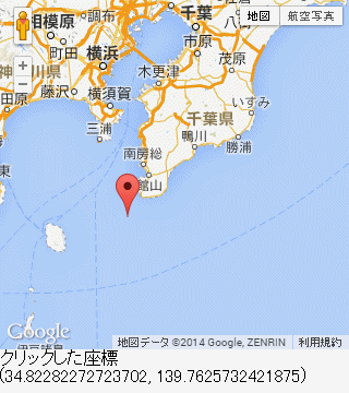
地図上でクリックされた座標を表示する
<div id="map_canvas"></div>
クリック位置の緯度と経度<br>
<span id="latlng"></span>
</body>
</html>
<!DOCTYPE html>
<html>
<title>地図上でクリックされた座標と住所を表示する</title>
<head>
<meta name="viewport" content="initial-scale=1.0, user-scalable=no" />
<style type="text/css">
html { height: 100% }
body { height: 100%; margin: 0; padding: 0 }
#map_canvas { width: 320px; height: 320px }
</style>
<script type="text/javascript"
src="http://maps.googleapis.com/maps/api/js?v=3.exp&sensor=false">
</script>
<script type="text/javascript">
function initialize() {
// 中心座標(35.0,140.0)、拡大率 8 で地図を map_canvas に表示する
var mapOptions = {
center: new google.maps.LatLng(35.0,140.0),
zoom: 8
};
var map = new google.maps.Map(document.getElementById('map_canvas'), mapOptions);
// ジオコーダー オブジェクトの作成
var geocoder = new google.maps.Geocoder();
// 地図上のクリック イベントを作成する
google.maps.event.addListener(map, 'click', function(e){
// 座標から住所を求める
var request = {latLng: e.latLng};
geocoder.geocode(request, function(results, status){
// クリック位置の住所を address に表示する
document.getElementById('address').innerHTML = '' + results[0].formatted_address;
// 住所位置にマーカーを表示する(クリック位置と住所位置は、必ずしも一致しない)
var marker = new google.maps.Marker({
map: map,
position: results[0].geometry.location
});
// 住所位置の緯度と経度を latlng に表示する
document.getElementById('latlng').innerHTML = '' + results[0].geometry.location;
});
});
}
</script>
</head>
<body onload="initialize()">
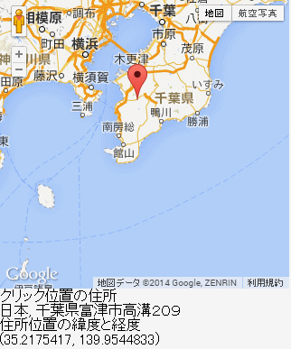
地図上でクリックされた座標と住所を表示する
<div id="map_canvas"></div>
クリック位置の住所<br>
<span id="address"></span><br>
住所位置の緯度と経度<br>
<span id="latlng"></span><br>
</body>
</html>
<!DOCTYPE html>
<html>
<title>イベントの ON/OFF</title>
<head>
<meta name="viewport" content="initial-scale=1.0, user-scalable=no" />
<style type="text/css">
html { height: 100% }
body { height: 100%; margin: 0; padding: 0 }
#map_canvas { width: 320px; height: 320px }
</style>
<script type="text/javascript"
src="http://maps.googleapis.com/maps/api/js?v=3.exp&sensor=false">
</script>
<script type="text/javascript">
var map;
var marker; // マーカー オブジェクト
var id_click = null; // マーカー クリック イベント ID
var infowindow; // 情報ウィンドウ オブジェクト
function initialize() {
// 中心座標(35.0,140.0)、拡大率 8 で地図を map_canvas に表示する
var latlng = new google.maps.LatLng(35.0,140.0);
var mapOptions = {
center: latlng,
zoom: 8
};
map = new google.maps.Map(document.getElementById('map_canvas'), mapOptions);
// マーカーを作成する
marker = new google.maps.Marker({
map : map,
position: latlng
});
// 情報ウィンドウの作成
infowindow = new google.maps.InfoWindow({
content: 'ここが中心'
});
}
// イベント開始
function StartEvent()
{
// マーカーがクリックされたら、情報ウィンドウが表示されるイベントの作成
if(!id_click){
id_click = google.maps.event.addListener(marker, 'click', function(){
infowindow.open(map, marker);
});
}
}
// イベント終了
function EndEvent()
{
if(id_click){
google.maps.event.removeListener(id_click);
id_click = null;
}
}
</script>
</head>
<body onload="initialize()">
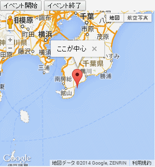
イベントの ON/OFF<br>
<input type="button" value="イベント開始" onclick="StartEvent();">
<input type="button" value="イベント終了" onclick="EndEvent();">
<div id="map_canvas"></div>
</body>
</html>
<!DOCTYPE html>
<html>
<title>情報ウィンドウ付きマーカーの複数表示</title>
<head>
<meta name="viewport" content="initial-scale=1.0, user-scalable=no" />
<style type="text/css">
html { height: 100% }
body { height: 100%; margin: 0; padding: 0 }
#map_canvas { width: 320px; height: 320px }
</style>
<script type="text/javascript"
src="http://maps.googleapis.com/maps/api/js?v=3.exp&sensor=false">
</script>
<script type="text/javascript">
var map;
var markers = [];
function initialize() {
// 中心座標(35.0,140.0)、拡大率 8 で地図を map_canvas に表示する
var mapOptions = {
center: new google.maps.LatLng(35.0,140.0),
zoom: 8
};
map = new google.maps.Map(document.getElementById('map_canvas'), mapOptions);
// ジオコーダー オブジェクトの作成
var geocoder = new google.maps.Geocoder();
// データファイル読み込み
var xhr = new XMLHttpRequest(); // IE7 以降
xhr.open('GET', './data.txt', false);
xhr.send();
// データは、CSV形式のため、先ず、行ごとに分割し、lines に入れる
var lines = xhr.responseText.split('\n');
// 次に各行をカンマごとに分割し、vals に入れる
// (vals[0] に地名、vals[1] に住所が入る)
for(var i=0; i<lines.length; i++){
var vals = lines[i].split(',');
// 住所から座標を求める
var request = {address: vals[1]};
geocoder.geocode(request, function(results, status){
// マーカーを追加
AddMarker(results[0].geometry.location, vals[0], vals[1]);
});
}
}
// マーカーの追加
function AddMarker(latlng, strTitle, strAddr)
{
// マーカーを作成する
var marker = new google.maps.Marker({
map : map,
position: latlng,
title : strTitle
});
// マーカーを配列に入れる
markers.push(marker);
// 情報ウィンドウの作成
var string = strTitle + '<br>' + strAddr;
var infowindow = new google.maps.InfoWindow({
content: string
});
// マーカーがクリックされたら、情報ウィンドウが表示されるイベントの作成
google.maps.event.addListener(marker, 'click', function(){
infowindow.open(map, marker);
});
}
</script>
</head>
<body onload="initialize()">
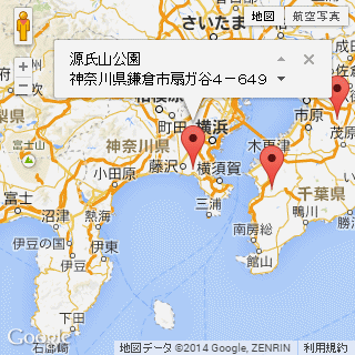
情報ウィンドウ付きマーカーの複数表示
<div id="map_canvas"></div>
</body>
</html>
--------------------------------------------------------------------------------
[data.txt]
創造の杜,千葉県千葉市緑区あすみが丘5−41
マザー牧場オートキャンプ場,千葉県富津市田倉940−3
源氏山公園,神奈川県鎌倉市扇ガ谷4−649−1
<!DOCTYPE html>
<html>
<title>GPS の ON/OFF</title>
<head>
<meta name="viewport" content="initial-scale=1.0, user-scalable=no" />
<style type="text/css">
html { height: 100% }
body { height: 100%; margin: 0; padding: 0 }
#map_canvas { width: 320px; height: 320px }
</style>
<script type="text/javascript"
src="http://maps.googleapis.com/maps/api/js?v=3.exp&sensor=true">
</script>
<script type="text/javascript">
var map;
var id_gps = null; // GPS の ID
var marker_gps = null; // マーカー オブジェクト
function initialize() {
// 中心座標(35.0,140.0)、拡大率 8 で地図を map_canvas に表示する
var mapOptions = {
center: new google.maps.LatLng(35.0,140.0),
zoom: 8
};
map = new google.maps.Map(document.getElementById('map_canvas'), mapOptions);
}
// GPS 開始
function RunGPS()
{
if(navigator.geolocation && !id_gps){
id_gps = navigator.geolocation.watchPosition(function(e){
// 緯度と経度を LatLng 形式に変換
var pos_gps = new google.maps.LatLng(e.coords.latitude, e.coords.longitude);
// マーカー消去
DeleteMaker();
// マーカー作成
marker_gps = new google.maps.Marker({
map : map,
position: pos_gps,
title : '現在地'
});
// 地図の中心を GPS 座標にする
map.setCenter(pos_gps);
});
}
}
// GPS 終了
function StopGPS()
{
// GPS 終了
if(id_gps){
navigator.geolocation.clearWatch(id_gps);
id_gps = null;
}
// マーカー消去
DeleteMaker();
}
// マーカー消去
function DeleteMaker()
{
if(marker_gps){
marker_gps.setMap(null);
}
}
</script>
</head>
<body onload="initialize()">
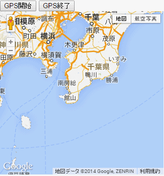
GPS の ON/OFF<br>
<input type="button" value="GPS開始" onclick="RunGPS();">
<input type="button" value="GPS終了" onclick="StopGPS();">
<div id="map_canvas"></div>
</body>
</html>
<!DOCTYPE html>
<html>
<title>ドラッグ可能クリックルート探索</title>
<head>
<meta name="viewport" content="initial-scale=1.0, user-scalable=no" />
<style type="text/css">
html { height: 100% }
body { height: 100%; margin: 0; padding: 0 }
table { height: 100% }
#map_canvas { width: 320px; height: 320px }
#map_sentence { width: 320px; height: 100% }
</style>
<script type="text/javascript"
src="http://maps.googleapis.com/maps/api/js?v=3.exp&sensor=false">
</script>
<script type="text/javascript">
var waypoint_max = 8; // business は 23
var routes = []; // waypts に始点と終点を含めたもの
var waypts = []; // 経由地点
var dirServ = null;
var dirDisp = null;
function initialize() {
// 中心座標(35.0,140.0)、拡大率 8 で地図を map_canvas に表示する
var latlng = new google.maps.LatLng(35.0,140.0);
var mapOptions = {
center: latlng,
zoom: 8
};
var map = new google.maps.Map(document.getElementById('map_canvas'), mapOptions);
// DirectionsService, DirectionsRenderer オブジェクト作成
dirServ = new google.maps.DirectionsService();
dirDisp = new google.maps.DirectionsRenderer({
draggable : true, // マーカー ドラッグ可能
preserveViewport: true // 中心座標固定
});
// 地図クリック イベント
google.maps.event.addListener(map, 'click', function(e){
// クリックされた座標を配列に入れる
AddPoint(e.latLng)
});
// ルート探索(地図)を表示
dirDisp.setMap(map);
// ルート探索(文字)を表示
dirDisp.setPanel(document.getElementById('map_sentence'));
// マーカーが追加されたり、ドラッグされた時のイベント
google.maps.event.addListener(dirDisp, 'directions_changed', function()
{
// マーカー情報取得
var res = dirDisp.getDirections();
var data = res.routes[0];
// buf にルート探索後の全経路を入れる
var buf = [];
buf.push(data.legs[0].start_location);
var i;
for(i=0; i<data.legs.length; i++){
buf.push(data.legs[i].end_location);
}
// optimizeWaypoints が true だったり、
// マーカーがドラッグされたりした場合の対策として
// routes に最適化される前の順番でドラッグ後のデータを入れる
for(i=0; i<data.waypoint_order.length; i++){
var index = data.waypoint_order[i];
routes[index] = buf[i];
}
});
}
// routes に座標を追加
function AddPoint(latlng)
{
if(waypoint_max + 1 < routes.length){
routes[routes.length-1] = null;
}
routes.push(latlng);
// waypts に座標を追加
CalcPoint();
}
// waypts に座標を追加
function CalcPoint()
{
waypts = [];
var i;
for(i=0; i<routes.length-2; i++){
if(waypoint_max > waypts.length){
waypts[i] = {location: routes[i+1]};
}
}
// ルート探索
if(routes.length > 0){
CalcRoute();
}
}
// ルート探索
function CalcRoute()
{
var req = {
origin : routes[0],
destination : routes[routes.length-1],
waypoints : waypts,
travelMode : google.maps.DirectionsTravelMode.DRIVING
}
dirServ.route(req, function(response, status){
dirDisp.setDirections(response);
});
}
// ルート リセット
function ResetRoute()
{
routes = [];
waypts = [];
dirDisp.setDirections({routes: []});
}
</script>
</head>
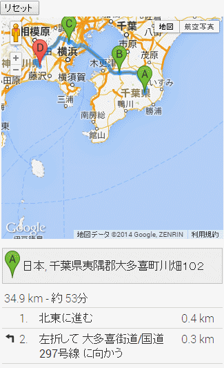
<body onload="initialize()">
ドラッグ可能クリック ルート探索<br>
<input type="button" value="リセット" onclick="ResetRoute();">
<table>
<tr>
<td id="map_canvas"></td>
</tr>
<tr>
<td id="map_sentence"></td>
</tr>
</table>
</body>
</html>